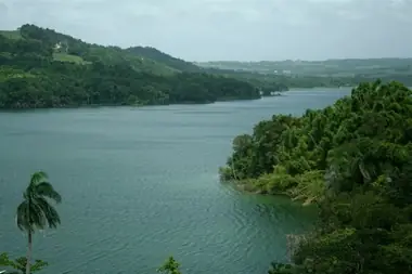
Lago Guajataca is a long, winding reservoir in the hills of northwestern Puerto Rico, shared by the municipalities of San Sebastián, Quebradillas and Isabela. Set among wooded hills, it is a favorite of freshwater anglers and paddlers. It is not a swimming lake or a beach destination. Come for a quiet morning of fishing or kayaking, a picnic with a lake view, or a scenic drive between the coast and the mountains, and pair it with the nearby Guajataca State Forest.
The lake and its dam
Construction of the dam began in 1928, and the reservoir filled at the end of the 1920s by damming the Río Guajataca. Most of its water comes from the Guajataca and the Río Chiquito de Cibao. The lake covers about 1.3 square miles and runs roughly 2.5 miles long and up to a mile wide, with a maximum depth of about 27 meters. Like most reservoirs on the island it has been slowly filling with sediment: by 1999 it had lost about 13 percent of its original storage capacity.
The dam is an earthen embankment about 120 feet high and 984 feet long, owned and operated by the Puerto Rico Electric Power Authority (PREPA). Its main purposes are water supply and irrigation for the northwest. A hydroelectric plant was built but no longer operates.
Hurricane María and the repairs
Lake Guajataca made international news on September 22, 2017, two days after Hurricane María. The dam's spillway at the northern end of the lake failed, operators warned that the whole dam could collapse, and the National Weather Service called for the evacuation of about 70,000 people living downstream in what it described as a life-threatening situation. The dam held. The first phase of emergency repairs was completed in November 2017, but about 10,000 residents, including farmers, faced water rationing afterward.
In 2023 the U.S. Army Corps of Engineers and PREPA, with FEMA funding, reached an agreement for permanent repairs and improvements. The Corps is handling design, engineering, contracting and construction oversight. The work includes restoring the hydroelectric capability and installing an early-warning system for emergency agencies, and completion has been targeted for 2028. While the work continues, check for any access restrictions near the dam before you go.
Fishing
Fishing is the lake's main draw. Species include peacock bass (tucunaré), largemouth bass (lobina), sunfish, perch, catfish, tilapia and threadfin shad. Shore fishing and sport fishing from boats are both popular.
Rules worth knowing:
- No live bait. A DRNA administrative order prohibits using aquatic and semi-aquatic organisms as bait in the island's reservoirs and rivers, and DRNA rangers enforce it.
- No nets, and no fishing from the boat ramps at the recreation area.
- Licenses. Check the DRNA's current requirements for recreational fishing licenses before you cast.
The recreation area in San Sebastián
The main public access point is the lakeside recreation area and wildlife refuge at Road 119, km 22.1, in the Aibonito barrio of San Sebastián. A 2015 profile described its facilities and rules: shore fishing areas, boat ramps, walking paths along the shore, and a historic water-level measuring tower near the dam. At that time it was open Tuesday to Sunday and on holidays, from 6:00 a.m. to 6:00 p.m., and drew tens of thousands of visitors a year. Those details are a decade old, so confirm current hours and conditions with the DRNA before you go.
The same rules list made clear what the area is not for. Swimming, camping, hunting, pets, campfires, hammocks, smoking, bicycles, fireworks and removing plants were prohibited. Private boats were allowed with all permits in order and engines up to 30 horsepower, and kayaks were welcome.
Kayaking and boating
A kayak is the best way to see the lake. Paddling along the wooded shoreline is quiet and unhurried, and many kayakers bring a rod to cast for bass. Go early in the morning, when the water is calm and before afternoon showers. Bring a life jacket for everyone, and remember there is no swimming, so stay in or near your boat. Low water can expose mud along the edges, which is slippery when launching or walking the shore.
Getting there
A car is necessary. The recreation area is on Road 119 in San Sebastián, a winding mountain road with lake views and roadside restaurants along the way. Take it slowly and enjoy the views. The Guajataka Scout Reservation, a Boy Scouts camp, borders the southern part of the lake.
Practical tips
- Bring water, food, sun protection and insect repellent. Services at the shore are limited.
- Weather. Showers can build quickly over the hills. Get off the water at the first sign of lightning.
- Leave no trace. Pack out fishing line, hooks and trash.
- Check conditions with the DRNA before driving out, especially while the dam repairs are underway.
Combine it with
The Guajataca State Forest in Isabela, with its karst trails and Cueva del Viento, is a short drive away and is often confused with the lake. Head down to the coast for an afternoon at Playa Jobos, or east to the Río Camuy Cave Park area. For food and lodging nearby, browse the Quebradillas directory.