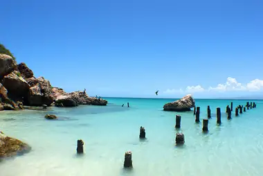
On a clear day, look south from the waterfront in Ponce and you will see a long, low island on the horizon, with a hump at one end and a lighthouse on top. That is Isla Caja de Muertos, "Dead Man's Chest," an uninhabited island about 8 kilometers (5 miles) off the south coast. It is a protected nature reserve with dry forest, turtle nesting beaches and clear water over sand and reef. A boat ride of roughly 20 minutes from Ponce gets you there, and for many people in the south it is the closest thing to a desert-island day. Before you go, though, you should know that the island's visitor facilities have been closed since the 2020 earthquakes, so a trip today is a simple beach-and-snorkel outing with no services on shore.
Current status: what is open and what is not
Caja de Muertos is managed by the Puerto Rico Department of Natural and Environmental Resources (DRNA). Hurricane María damaged much of the reserve's infrastructure in 2017, and the earthquakes that struck the south coast in January 2020 did further damage. The DRNA buildings on the island, including the facilities that once housed rangers and visitors, have remained closed since then. In September 2025, Primera Hora reported that the reserve's land area was still closed while the government sought federal funds for repairs, including restoration of the 1887 lighthouse.
That has not stopped people from coming. In October 2026, El Nuevo Día reported that dozens of people still visit, mostly on weekends, arriving in their own boats or on jet skis. The same report said that after vandals damaged a seismograph on the island, the DRNA's ranger corps (the Cuerpo de Vigilantes) would step up to daily patrols by boat, along with daily drone flights.
In practice, this means you should not expect bathrooms, drinking water, shade structures, lifeguards or a ranger station. Do not count on hiking to the lighthouse either. Ask your boat operator what is currently permitted on shore, and follow any instructions from DRNA rangers you meet there.
Why the island is worth the trip
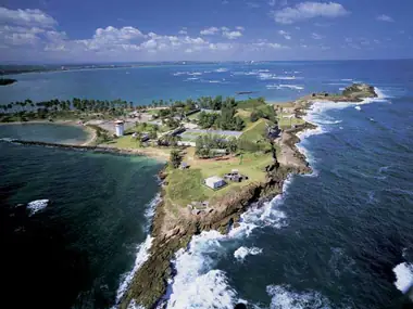
The island runs about 3 kilometers (2 miles) from northeast to southwest and covers roughly 1.5 square kilometers. Most of it is flat and low, covered in dry coastal forest with cacti and scrub, rising at the southwest end to a hill of about 52 meters (170 feet). The climate is dry, so the water is often very clear. Two smaller cays, Morrillito just off the southwest tip and Berbería several kilometers to the northeast, are part of the same reserve.
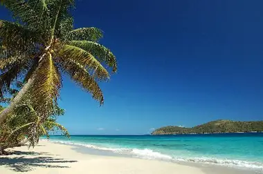
The Puerto Rico government declared it a nature reserve in 1980, mainly to protect sea turtles. The hawksbill, an endangered species, nests on its beaches. The island's beaches include Playa Pelícano on the western side next to the dock, once certified as a Blue Flag beach, and Playa Blanca to the northwest. Playa Larga, on the southeast side facing the open Caribbean, is protected and not open to visitors.
The lighthouse and the legends
The lighthouse on the island's highest hill was begun by the Spanish government in 1880 and completed in 1887. It was automated in 1945 and still works as a navigation light. The DRNA restored it in the past and once used it to house a small museum. It is now among the structures awaiting repair.
The name comes from the island's outline. Seen from parts of the south coast, it looks like a body lying on a table or in a coffin. The DRNA credits the name to the 18th-century French writer Jean-Baptiste Labat. Pirate stories cling to the place. The best known is the legend of a Portuguese pirate named Almeida who hid his wife's coffin in a cave on the island. Treat those stories as folklore, not history.
Getting there
There is no public ferry. The Puerto Rico Ports Authority stopped running public trips in 1993, and since then private operators have carried visitors. Boats leave from Paseo Tablado La Guancha, the boardwalk in the Playa district of Ponce, where there is parking. One operator currently advertising trips is Waterland Adventure, which lists day trips to Caja de Muertos and to the much smaller Isla Cardona, closer to the harbor, from La Guancha. Its packages have included snorkel gear, drinks and food, and chairs and umbrellas, but what is included varies by package. Check the operator's website for current departures, inclusions and prices, and book ahead, especially for weekends. Private boat charters are another option.
The crossing is short, but it is open water, so people prone to seasickness should take precautions before boarding.
What to do there
- Swim and relax. Stick to the western beaches near the dock. The southeast shore faces the open Caribbean and is protected and off limits.
- Snorkel. There are reefs off the northeast side of the island that you can only reach by boat. Ask your operator which spots they visit.
- Look at the dry forest. The cacti and scrub are a sharp contrast with the green mountains you see across the water. If you see a turtle, keep your distance and let it pass.
Practical tips
- Bring everything. Water, food, sun protection and shade are on you unless your package includes them. There is nothing to buy on the island.
- Sun. Shade is scarce and the island is hot. Bring a hat, a long-sleeved shirt for the boat and plenty of reef-safe sunscreen.
- Footwear. Water shoes help on rocky or reefy entries.
- Pack out your trash. No one collects it. Leave no food or belongings behind.
- Respect closures. Stay out of roped-off nesting areas and closed buildings, and do not climb on damaged structures.
- Weather. Check the National Weather Service marine and rain forecast for the south coast before you go. Trips can be canceled in rough seas.
- Timing. Weekdays are quieter. Weekends bring private boats and more noise.
Combine it with
Boat trips leave in the morning and return by mid-afternoon, which leaves time for an evening snack on the boardwalk at La Guancha. On another day, spend time in downtown Ponce around Plaza Las Delicias, then drive up the hill to Castillo Serrallés and the observation cross at El Vigía, where you can look back out at the island. For another small-island day on the south coast, head west to Gilligan's Island in Guánica.
Good to know
- Where: about 8 km (5 mi) south of Ponce, in the Caribbean Sea.
- Managed by: DRNA, as a nature reserve since 1980.
- Access: private boat operators and charters from La Guancha. No public ferry.
- DRNA facilities have been closed since the 2020 earthquakes. There are no services on shore.
- The lighthouse dates from 1887 and awaits restoration.